For municipalities, counties & fire safe councils
Your residents are losing their insurance. Make your mitigation dollars go 10x further.
Assess every parcel. Deploy capital where it matters most. Prove the results with satellite verification. All from one platform.
Free 7-day trial for .gov email addresses
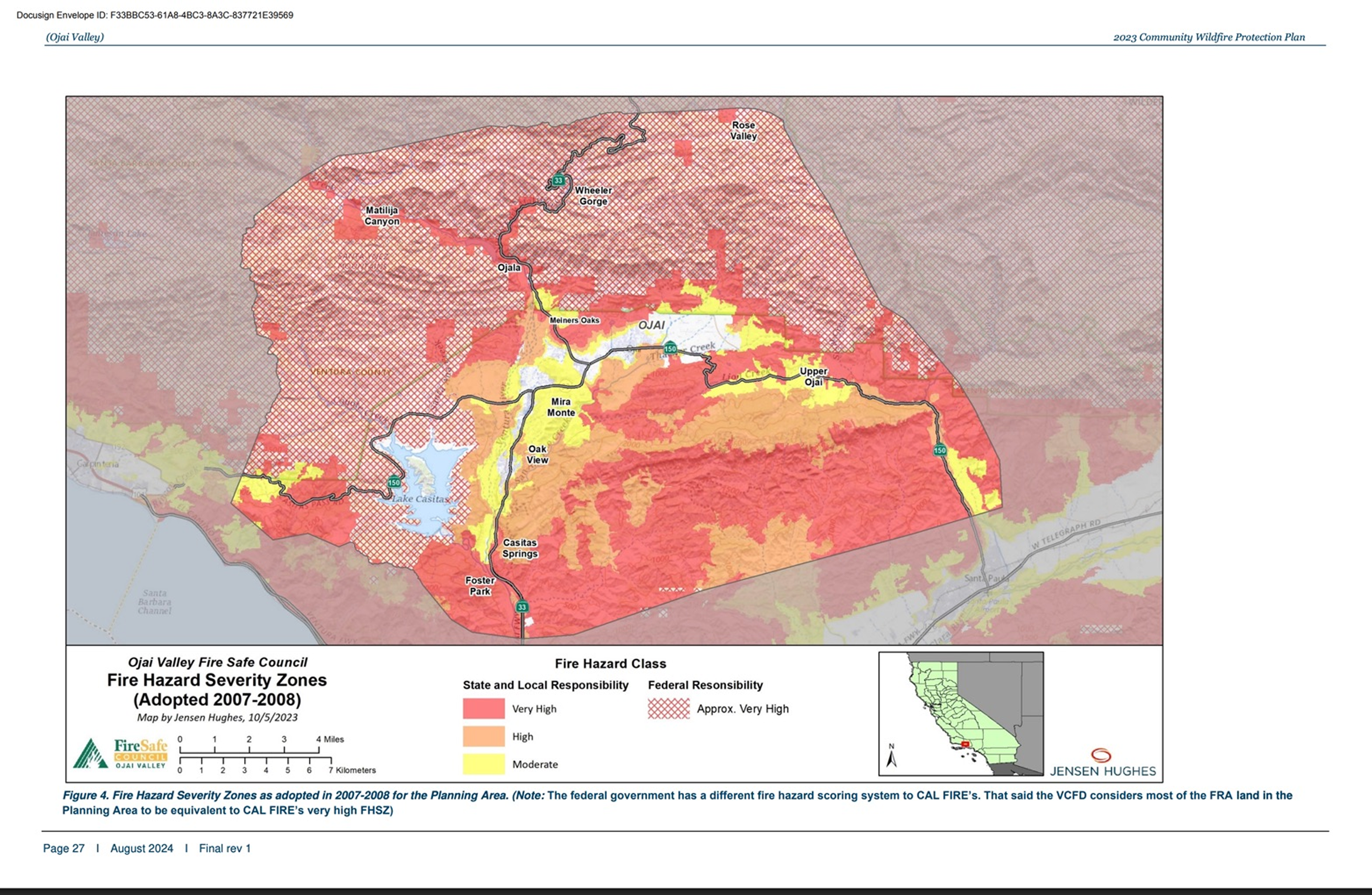
Typical fire risk map
TMRW — parcel-level risk intelligence
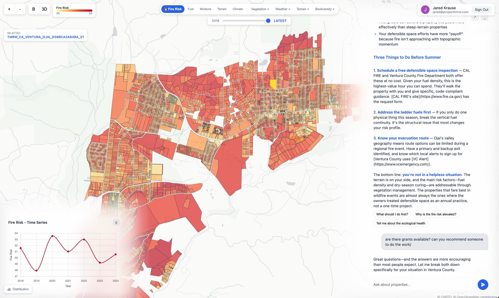
Community-wide intelligence
See every parcel. Ask any question.
Run reports on any property in your jurisdiction. Filter by risk level, neighborhood, vegetation type — whatever you need. No GIS expertise required.
Parcel-level risk scores
Every property scored individually — not zone averages. Fire, flood, drought, heat.
Built for anyone
No GIS training needed. Ask questions in plain language. The platform speaks all major languages fluently.
Reports on demand
Generate reports by neighborhood, risk tier, income bracket, or any other variable you need.
Capital deployment
Know exactly where every dollar goes.
Stop guessing. TMRW identifies the highest-leverage properties, the highest-ROI interventions, and tracks every dollar from allocation to verified outcome.
Without TMRW
“We should spend $1M on mitigation.”
“How about $7M?”
“Let’s split it — $3.5M.”
No risk model. No ROI. No way to verify.
With TMRW
Identify highest-risk parcels across your jurisdiction
See exact ROI for every intervention before you spend
Fund the work, verify the outcome with satellite data
Every dollar tracked. Every outcome verified.
Target who needs it most
Segment residents by risk level, income bracket, geography, or any socio-economic variable. Deploy resources to the people and places where they’ll have the biggest impact.
Grant administration
Administer grants without the headaches.
Citizens apply through TMRW. We channel funding to qualified providers, track the work, and document the results. You get a full record of every dollar deployed and every outcome achieved.
Citizens apply
Through TMRW — no paperwork for your staff
Funds matched
FEMA, state, county, and local grants surfaced automatically
Work completed
Qualified contractors do the work and document it
Outcome verified
Satellite monitoring confirms risk reduction
Verification & reporting
Prove it worked.
Satellite-verified before-and-after data for every intervention. Insurance-legible reports that give you leverage to negotiate on behalf of your residents.
Satellite
Continuous monitoring verifies every change — before and after, with timestamped proof.
Reports
Generate compliance documentation, council presentations, and insurance-ready reports on demand.
Leverage
Quantified risk reduction gives you real negotiating power with insurance companies on behalf of your community.
Flexible deployment
Deploy it your way.
Start with your department, or roll it out to your entire community. Scale up when you’re ready.
For your team
Per-seat access for planning, fire, or emergency management staff. See every parcel, run reports, ask questions.
For your residents
Give residents free or subsidized access. Cover your whole city, a high-risk zone, or a specific number of seats.
For your budget
Deploy mitigation funds through the platform. We identify the highest-ROI targets, fund the work, and verify outcomes.
Common questions
Straight answers.
Ready to protect your community?
Start with a free trial, or talk to our team about a deployment that fits your needs.
Free for .gov email addresses